18.4 miles, 7,700', 17h1min RT
Climbers: Sean, Terry, Abe
People throw the noun 'epic' around too freely, so I'll resist the urge to do so. Nonetheless, any seventeen-hour day, even if it goes according to plan, has to be viewed as more than simply a walk in the park. This was such a trip.
 |
| 4/30/2011 - Crestone Peak (14,294') from South Colony Rd. (9,467') 18.4 miles, 7,700', 17h1min RT |
Cale's mom flew in to the Springs to spend some time with him this weekend, so I found myself with a rare school-year weekend free. Sure, I've got a little fun run coming up next weekend, but the need for some spring mountain fun trumped discretion. Trouble wasn't too far away, as a climbing buddy of mine, Terry, was looking for partners on a spring ascent of Crestone Peak via the snowed-in "red gulley." Besides a winter mountaineering class I took earlier in the month, I hadn't spent any time in the mountains since October! I'd been up "the Peak" via the red gulley twice already, but that didn't deter me from contacting Terry to tell him I was in. I had my reasons.
- This was a rare chance to visit the Crestones in full-on spring conditions.
- Ascending a mountain with crampons and an axe is a totally different experience than scrambling up solid rock.
- It's hard to find partners for the more challenging peaks in snow.
- It would be a great way to get some serious aerobic work at altitude without incurring the higher impact and recovery cost caused by running.

There is much confusion when people speak of the "South Colony" trailhead. Let me try to clarify using distances.
- 0.0 miles (8,800') - the lower trailhead. This is located at the very foothills of the Sangres in the Wet Mountain valley, before trees even begin to appear.
- 1.2 miles (9,467') - where we were able to drive before snow cover made the road impassible.
- 2.7 miles (9,950') - the NEW upper trailhead. As of August 2009, this is the furthest point that vehicles are permitted to drive. There is a parking lot, gate, and register here.
- 5.5 miles (11,040') - the OLD upper trailhead. The road between the new and old upper trailheads has now been closed for over a year and a half. It used to be a very rough road, impassible for all but the heartiest 4WD vehicles.
Terry had been in contact with two other guys, Abe and Charlie. (a bunch of other people wanted to join the trip, but none had avi gear, so Terry rightly turned 'em away) We met them at the "trailhead" at 0400, exchanged introductions, and were on our way up by 0430.

 | |
| It's still winter up there! |

 |
| Broken Hand Pass is the low point between Broken Hand Peak(L) and Crestone Needle(R) |
 |
| Lower South Colony Lake is down there...somewhere! |
 |
| View of Crestolita (I think) from atop Broken Hand Pass. |
We barreled down the other side of Broken Hand Pass, relieved to be done with that mess and excited to get a glimpse of our real objective. Going was still not quick, though. We got to Cottonwood Lake, exchanged crampons for snowshoes, skirted the lake, and enjoyed our whitewashed surroundings as we made our way to the base of the red gulley. In the Cottonwood drainage, it actually felt hot for the first time all day!
 |
| Cottonwood Lake |
 |
| Lots of snow. |
 |
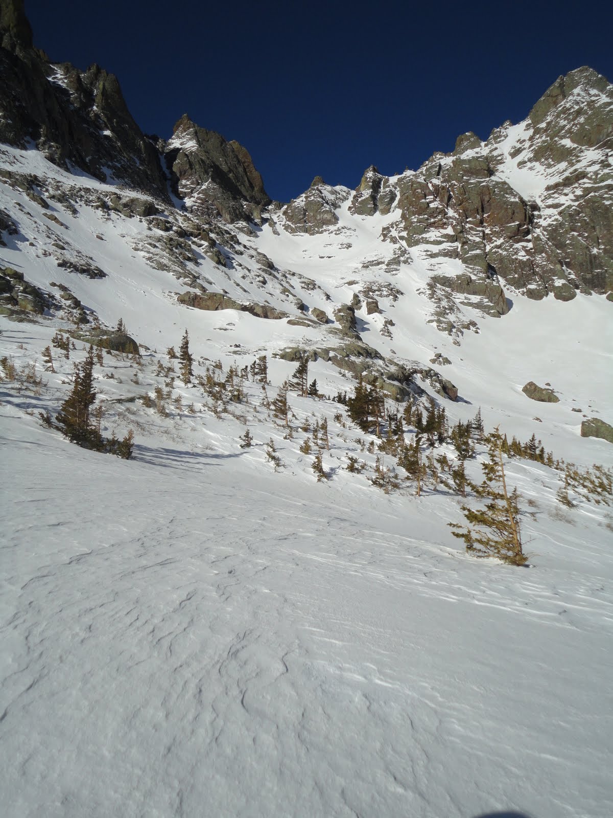
| The red gulley snakes up the center of this picture. The summit is just to the left. The gulley isn't so red this time of year. |
 |
| A closer look at the gulley. We entered from the right on the snow band just below center. |
 |
| Crestone Needle, as viewed from the red gulley. |
 |
| Going up! |
 |
| The southern Sangres. The Sierra Blanca massif can be seen in the background. |
 |
| Abe and Pico Asilado |
 |
| Almost there |
Finally, we hit the 14,200' top of the gulley. All that remained was a short scamper over fun rock...or so I was hoping. The recent storms had deposited enough new snow on the south-facing slabs that no simple route was evident. Furthermore, the traverse over to the ridge was corniced over with stuff that looked (and felt) like it might go any minute. Ten and a half hours and many miles in, we decided to call it a day.
 |
| Terry topping out on the gulley. |
 |
| hero shot |
For anyone who has done this route from South Colony in the summer, you know how miserable the re-ascent of Broken Hand Pass can be. While the snow cover on this side was scant, we still needed snow shoes to avoid knee-high postholing. I don't think one non-explicative was muttered the entire way back up, as all three of us were in our own little private hells. Even the stopping to switch out footwear became arduous. (In total, I think we switched either into or out of snowshoes or crampons a total of seven times) The descent into South Colony wasn't much better than the initial climb, and the thought of knowing we still had hours of trudging ahead overshadowed the beauty of the closing light on the high peaks surrounding us.
 |
| Getting ready to return down Broken Hand Pass. |
We finally made it back to the cars at 9:30PM. It had been by far the longest day of my life - surpassing my old longest day by a good four hours. While I wasn't too beat up physically, I felt like a walking zombie from lack of sleep. The three of us struggled to enjoy our post-climb Old Chub's. Terry and I said goodbye to Abe and began the drive back to Colorado Springs. I maybe said two words to Terry the entire drive home as I kept nodding off. I don't know how he stayed awake. For all I know, he didn't. I was too tired to tell.
 |
| Saying good bye to the Crestones. |
This doesn't qualify as an epic, as we didn't call SAR, get off-route, or do anything entirely sketchy. However, just the time spent on our feet was staggering. Top ultra runners can complete 100 miles in seventeen hours. The cutoff for Ironman finishers is seventeen hours! While we didn't do a 100-miler or an Ironman, though, we did feel like we accomplished something. A great journey in bluebird spring conditions to a beautiful part of the state - can't ask for much more than that.
I call bullshit. This is EPIC.
ReplyDeleteI 2nd the motion. That is epic! Did you guys happen to grab a shot from BHP looking up the south couloir of the Needle?
ReplyDeleteTim, I did not get a good shot of the needle's south couloir. It appeared to be holding snow as well, but that's all I got for ya. Sorry!
ReplyDeleteI kind of wanted to give that one a shot.
Holy shitte! I think you guys get like an A+++ for effort. I would be so demoralized to see that ridge in such shape once at the top. Hats off to you for making what was one hell of a tough call.
ReplyDelete-Kiefer
Hey Kiefer,
ReplyDeleteI noticed Abe and you joined up for a fun little jaunt in the Sangres last week. Good stuff.
As for it being a tough call...nah. It was pretty easy. When I'm not comfortable with something, I don't go and that's that.
Epic is a great work. I like to use it a lot. Also there is the word majestic that people don't usually use.
ReplyDelete